


Hi
Continuation of my mtw3dviewer project https://github.com/tomi-l/mtw3dviewer
I got a collaborator and we are working on it together now
I created a new branch for reading map format and we managed to get a working prototype now. There are very few clues about how map format works and pretty much the only source is this ancient thread https://forums.totalwar.org/vb/archi...hp/t-5259.html. Regardless we managed to reverse engineer vertex data part so far. I'll write a more robust documentation later but here's a short description how it works.
I have a custom flat map. Let's start with the header which is 9 bytes:
14 00 05 00 00 7C 6A 00 00
1400 is ushort which is the dimensions of the map. In this case 20, which makes the map 20x20
0500 is ushort which is the number of "subdivisions" per tile, we'll come to this later
00 is unknown but seems to always be the same
7C6A0000 is the size in bytes of the vertex data + texture data block
Now that we have the header parsed we can start parsing vertex data. Vertex data is arranged so that main nodes come first, and then each main node has additional 4 vertices of "control nodes". Number of control nodes refers to the subdivisions information (1+4=5)
Each node is a vertex of 12 bytes with following structure:
00 00 00 00 | 34 E3 FF FF | 00 A0 00 00
uint XCoordinate
int Height
uint YCoordinate
Since we established from the header that dimensions are 20x20 we know that the next 21*21 blocks of data are main nodes.
Next comes the control node part for each main node, they are of same structure but behave differently.
For each main node there are 4 control nodes:
00 08 00 00 | 34 E3 FF FF | 00 A8 00 00
00 10 00 00 | 34 E3 FF FF | 00 A0 00 00
00 08 00 00 | 34 E3 FF FF | 00 98 00 00
00 00 00 00 | 34 E3 FF FF | 00 A0 00 00
These nodes refer to the coordinates of the main node's neighboring tiles. In order:
Top left neighbour, up neighbour, left neighbour and the parent main node itself
Some of these coordinates can be out of bounds (for example for the first tile) so they are not actually used. There may be additional uses for this in mtw's smoothing algorithm.
With this information we can form a quad consisting of main node and 4 control nodes. This quad is a single tile:
Parsing the heights from the control nodes we deduced that each main node can manipulate vertices from it's neighboring quads.
In the illustration there are 2x2 tiles. Other main nodes are marked red, but the one we are currently parsing (marked green) can manipulate vertices from it's neighbours and it's own tile (marked purple):
The whole structure is confusing and remains a mystery why it's done this way but it must have something to do with the game's smoothing algorithm. Speaking of smoothing algorithm, I pretty much deem it impossible to reverse engineer so it'll probably just be easier to write own one.
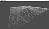
Here's a picture of Bannockburn:

 Reply With Quote


Bookmarks