Second Line Discussion
Keltic Foundation, Consolidation, Collapse, and Abandonment of Hesse, Germany
draft
The Late LaTene Chiefdom of the Ubii
Introduction
Gaius Julius Caesar mentioned the Ubii in connection to the Suebi’s expulsion and exodus of the Usipetes and Tenchteri, which occurred between 58 and 55 BC. He provides a basic description of this tribe and mentioned that he met with their ambassadors on several occasions. Furthermore, Caesar inferred that he had concluded an alliance with them and after crossing over the Rhine conducted a joint punitive campaign against the Suebi.
From Julius Caesar-The Gallic Wars, Book 4, Chapter 4:
Ad alteram partem succedunt Ubii, quorum fuit civitas ampla atque florens, ut est captus Germanorum; et paulo, quamquam sunt eiusdem generis, sunt ceteris humaniores, propterea quod Rhenum attingunt multum ad eos mercatores ventitant et ipsi propter propinquitatem quod Gallicis sunt moribus adsuefacti. Hos cum Suebi multis saepe bellis experti propter amplitudinem gravitatem civitatis finibus expellere non potuissent, tamen vectigales sibi fecerunt ac multo humiliores infirmiores redegerunt.
Rendering:
In the other direction are the Ubii, as ample and prosperous a state as Germany may provide. Although only a small nation they are civilized. This is because they largely border the Rhine where merchants regularly come and through proximity have become directly familiar with the Gallic manner. Often the Swabians severely test them in battle. Despite a great weight in numbers they are unable to expel this nation from its homeland. Nonetheless they are subject to tribute and are much weakened, reduced, and humbled.
Caesar continued to outline the allance between Rome and the Ubii, and mentioned their conflicts with the Swabians and Keltic Sugambri. Cassius Dio tells us that in the time of Augustus, they were eventually expelled, in the course of the Chatti establishing a new homeland, in the modern German state of Hesse. Thus, we understand that the late LaTene Keltic chiefdom identified in southwestern Hesse represents the Ubii and that their capital was the Heidetränk Oppidum.
The Heidetränk Oppidum
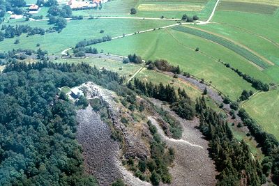
The huge Heidetränk Oppidum spans the Heidetränkbaches valley within the Taunus Highlands located about 16 km northwest of Frankfurt am Main. Overall, the settlement extends from the fortress situated on the Altenhöfe (50°13'43.66"N 08°30'35.97"E) in the southwest to the Goldgrube on the northwest (Figure 1). Furthermore, the main Oppida is surrounded by a number of small fortified settlements, the largest of which are the Altkönig and Gickelsburg fortresses. The smaller fortress settlements include the Hunerberg, Heidengraben, Blerbeskopf, and Rosskopf sites; as well as five even smaller fortified farmsteads. Unfortunately, almost no systematic archaeological investigations have been conducted at any of these important sites (Maier 1985).
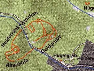
Figure 1. General Plan of the Heidetränk Oppidum Fortifications.
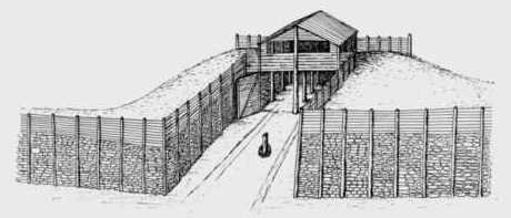
The site appears to been founded in the 3rd century BC as two discrete middle LaTene fortresses on the Altenhöfe and Goldgrube ridges. These forts were expanded and later linked by extensive bank and ditch murus gallicus type walls in the 2nd century BC. The main gate appears to be located in the northeastern wall of the site. Numerous secondary gates are found along the entire walled parameter of the settlement. A graphic reconstruction of the main gate is provided below (Figure 2). When completed, the length these fortifications eventually reached approximately 10 kilometers and enclosed an area of about 130 ha, which is even larger that most medieval towns. Within the enclosed area are literally hundreds of terraces and platforms that supported thousands of residential structures (Maier 1985). For satellite and ground photos of the Altenhöfe Locus see the link provided below.
The Heidetränk site seems to have been a flourishing hub for trade near the northern frontier of Keltic Germany. Intrusive artifacts also demonstrate the importance of trade in Baltic amber, Italian wine, bronze toiletry items and jewelry manufacted along the lower Rhine (Roymans 2005), as well as a large number of coins minted throughout central Europe. Although located in an area many researchers consider a cultural backwater, this community is recognized as the fourth largest Keltic settlement in all of Europe. For a map showing the extent of the greater Heidetränk community, see the link below (Maier 1985).
The Heidetränk Oppidum in the 2nd and early 1st centuries BC, appears to represent a major regional center. Extensive collections of locally made ceramics, weapons, coins, and jewelry indicate that this settlement was an important manufacturing focal point. Some have proposed that this settlement controlled the important iron and salt deposits in the Taunus Mountains and at Bad Nauheim respectively. However, by the middle of the 1st century the site appears to have gone into a rapid decline until it was abandoned in 10 BC, with the beginning of Roman occupation (Maier 1985).
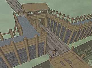
Figure 2. Reconstruction of the Heidetränk Oppidum main gate.
The Altkönig and Gickelsburg Fortresses
Atop a steep hill situated about half a kilometer southwest of Heidetrank, are the massive stone walls of the Altkönig fortress (50°12'41.65"N 08°28'56.81"E). This site was founded as a contemporary of late Hallstatt and early LaTene (5th and 4th centuries BC) tumulus tombs found at Glauberg (Ferdinand 1985). For satellite and ground photos of the Altkönig fortress see the link provided below.
Several kilometers northeast of Heidetrank is the Gickelsburg fortresses situated on a southeast trending ridge (50°16'18.49"N 08°35'36.93"E). Based on the limited evidence recovered from this site, it appears to have had a history very similar to that of the Altkönig Fortress. Although both settlements declined in importance in the 2nd century, they continued to be occupied into the 1st century BC. Their abandonments in the late 1st century BC seemed to have corresponded to the general pattern of Keltic withdraw from Hesse as witnessed in the archaeological record.
References Cited
Roymans, Nico 2005
Ethnic Identity And Imperial Power: The Batavians In The Early Roman Empire, Amsterdam University Press.
Maier, Ferdinand 1985
Das Heidetrank-Oppidum: Topographie Der Befestigten Keltischen Hohensiedlung Der Jungeren Eisenzeit Bei Oberursel Im Taunus, Deutsches Archaologisches Institut.


 Reply With Quote


Bookmarks