


Are you kidding? Please give me a link where I can check the current state of EBII.
Anyway, here comes Italy.
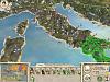
You may note the following improvements:
- Sicily is bigger with more accurate hills, towns and ports.
- A land bridge from Rhegium to Messana makes sure that Rome actually goes to encounter the Carthaginians in Panormus.
- Better design for ports of Tarentum and Brundisium (yet to build)
- Regional borders in Italy are as close as possible to historic (and modern) borders (actually there has been little change over 2000 years). Especially the problem in southern Italy (where cities didn't correspond to regions) has been solved in a satisfying way: Bruttium - Rhegium; Lucania - Tarentum; Apulia - Brundisium; Magna Graecia (or Calabria) - Croton.
- The road system is as close as possible to Roman roads. You can find Via Appia, Via Valeria, Via Salaria, Via Cassia, Via Aurelia, Via Flaminia, and Via Aemilia.
- more accurate design of places like Gulf of Naples, Elba, Lagoon of Ravenna and more.
- Accurate design of the islands in the Adriatic Sea. Corresponding ports in Iader, Pharos, Rhizon, Epidamnus, Corcyra. Islands like Pharos and Corcyra sometimes took me days to get them as accurate as you can see them now.

 Reply With Quote
Bookmarks