Results 1 to 30 of 153

Thread: The Europa Barbarorum Wonders Project

Hybrid View

Previous Post Previous Post   Next Post Next Post
  1. #1
    Member Member NikosMaximilian's Avatar
    Join Date
    Sep 2009
    Location
    Buenos Aires, Argentina
    Posts
    78

    Default Re: The Europa Barbarorum Wonders Project

    Proposed Wonder: The Incense Route


    "The Incense trade route or the Incense Road of Antiquity comprised a network of major ancient trading routes linking the Mediterranean world with Eastern sources of incense (and spices), stretching from Mediterranean ports across the Levant and Egypt through Arabia to India. The incense trade flourished from South Arabia to the Mediterranean between roughly the 3rd century BCE to the 2nd century CE.[1] The Incense Route served as a channel for trading of goods such as Arabian frankincense and myrrh;[1] Indian spices, ebony, silk and fine textiles;[2] and East African rare woods, feathers, animal skins and gold.[2]"
    I think it would be good to add some extra lure to those regions in Africa. Even with all the current wonders and fertilty, I believe it doesn't truly represent the amount of trade the region had, specially the naval trading routes to India.

    Proposed Wonder: Curonian Spit (Kuršių Nerija)


    "Human habitation of this elongated sand dune peninsula, 98 km long and 0.4-4 km wide, dates back to prehistoric times. Throughout this period it has been threatened by the natural forces of wind and waves. Its survival to the present day has been made possible only as a result of ceaseless human efforts to combat the erosion of the Spit, dramatically illustrated by continuing stabilisation and reforestation projects.

    According to Baltic mythology, the Curonian Spit was formed by a giantess, Neringa, who was playing on the seashore. This child also appears in other myths (in some of which she is shown as a young strong woman, similar to a female version of the Greek Heracles).

    The Curonian Spit was formed about 5,000 years ago. From ca. 800 to 1016, it was the location of Kaup, a major pagan trading centre which has not been excavated yet
    Increase in tradable goods? A bit more of luring players towards the Baltic.
    5% happiness bonus?

    Proposed Wonder: Thracian Tomb of Kazanlak


    "The tomb is part of a large Thracian necropolis. It comprises a narrow corridor and a round burial chamber, both decorated with murals representing a Thracian couple at a ritual funeral feast. The monument dates back to the 4th century BC and has been on the UNESCO protected World Heritage Site list since 1979. The murals are memorable for the splendid horses and especially for the gesture of farewell, in which the seated couple grasp each other's wrists in a moment of tenderness and equality. The paintings are Bulgaria's best-preserved artistic masterpieces from the Hellenistic period.

    Discovered in 1944, it is located near Seutopolis, the capital city of the Thracian king Seutes III. The tholos has a narrow corridor and a round burial chamber, both decorated with murals representing Thracian burial rituals and culture. These paintings are Bulgaria’s best-preserved artistic masterpieces from the Hellenistic period.
    Hapiness bonus?

    In the same mould, it could be used the Thracian Tomb of Sveshtari
    Last edited by Ludens; 12-15-2009 at 21:21. Reason: merged posts

    Completed campaigns:


    Ongoing campaigns:

  2. #2
    EB Nitpicker Member oudysseos's Avatar
    Join Date
    Feb 2006
    Location
    Dublin, Ireland
    Posts
    3,182

    Default Re: The Europa Barbarorum Wonders Project

    Nikos, that's an excellent start. Any more information about any of those would be great!


    Just a note to myself- Oenach Tailten. Info to come.
    οἵη περ φύλλων γενεὴ τοίη δὲ καὶ ἀνδρῶν.
    Even as are the generations of leaves, such are the lives of men.
    Glaucus, son of Hippolochus, Illiad, 6.146


  3. #3

    Default Re: The Europa Barbarorum Wonders Project

    the palace of knossos seems a great wonder

    maybe someone in crete after visiting the palace could get some quality as a "spacial organiser" since after visiting the "labirinth" they would compreend how to better use space ? plus 1+ influence for being the "guardian" of the athenian/greek superiority against the animalities of the minoans ? or descendent of theseus

    http://en.wikipedia.org/wiki/Knossos

    The site has had a very long history of human habitation, beginning with the founding of the first Neolithic settlement circa 7000 BC. Over time and during several different phases that had their own social dynamic, Knossos grew until, by the 19th to 16th centuries BC (during the 'Old Palace' and the succeeding 'Neo-palatial' periods), the settlement possessed not only a monumental administrative and religious center (i.e., the Palace), but also a surrounding population of 5000-8000 people.

    The palace is about 130 meters on a side and since the Roman period has been suggested as the source of the myth of the Labyrinth, an elaborate mazelike structure constructed for King Minos of Crete and designed by the legendary artificer Daedalus to hold the Minotaur, a creature that was half man and half bull and was eventually killed by the Athenian hero Theseus.

    The 6 acres (24,000 m2) of the palace included a theatre, a main entrance on each of its four cardinal faces, and extensive storerooms (also called magazines). The storerooms contained pithoi (large clay vases) that held oil, grains, dried fish, beans, and olives. Many of the items were created at the palace itself, which had grain mills, oil presses, and wine presses. Beneath the pithoi were stone holes used to store more valuable objects, such as gold. The palace used advanced architectural techniques: for example, part of it was built up to five stories high.

    Liquid management
    The palace had at least three separate liquid management systems, one for supply, one for drainage of runoff, and one for drainage of waste water.

    Aqueducts brought fresh water to Kephala hill from springs at Archanes, about 10 km away. Springs there are the source of the Kairatos river, in the valley of which Kephala is located. The aqueduct branched to the palace and to the town. Water was distributed at the palace by gravity feed through terracotta pipes to fountains and spigots. The pipes were tapered at one end to make a pressure fit, with rope for sealing. The water supply system would have been manifestly easy to attack.[citation needed] No hidden springs have been discovered as at Mycenae.

    Sanitation drainage was through a closed system leading to a sewer apart from the hill. The Queen's Megaron contained an example of the first water flushing system toilet adjoining the bathroom. This toilet was a seat over a drain flushed by pouring water from a jug. The bathtub located in the adjoining bathroom similarly had to be filled by someone heating, carrying, and pouring water, and must have been drained by overturning into a floor drain or by bailing. This toilet and bathtub were exceptional structures within the 1300-room complex.

    just my 2 cents and hope this helps

  4. #4
    The Rhetorician Member Skullheadhq's Avatar
    Join Date
    Apr 2008
    Location
    Antioch
    Posts
    2,267

    Default Re: The Europa Barbarorum Wonders Project

    I've got one, for the province that includes nowadays Netherlands, it's called Terpen or Artificial dwelling hill
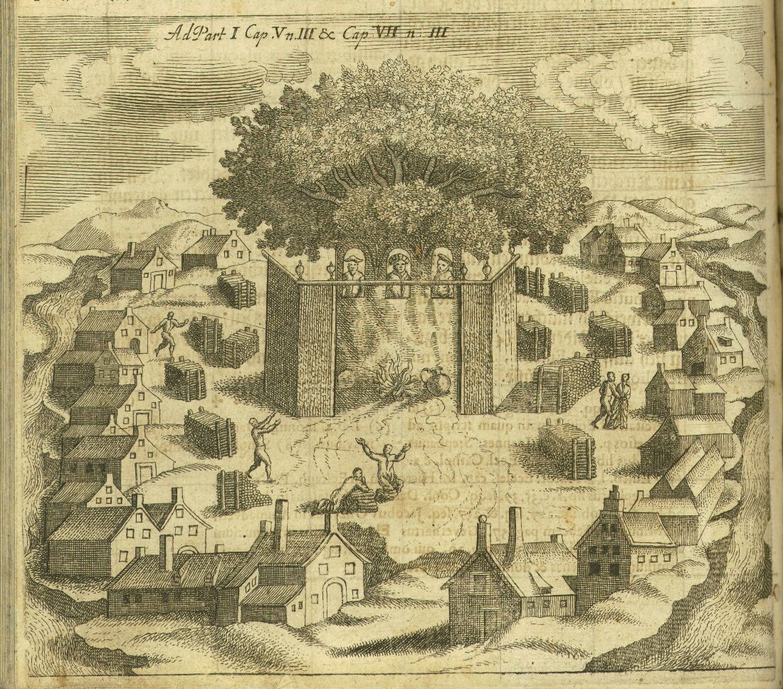
    An artificial dwelling hill (known as Terp, Wierde, Woerd, Warf, Warft, Werf, Wurt and Værft) is a mound, created to provide safe ground during high tide and river floods. These hills occur in the coastal parts of the Netherlands (in the provinces of Zeeland, Friesland and Groningen), in southern part of Denmark and in Germany where, before dikes were made, tides interfered with daily life. They also occur in the Rhine and Meuse river plains in the central part of the Netherlands.
    In the Dutch province of Friesland, an artificial dwelling hill is called terp (plural terpen). Terp means "village" in Old Frisian and is cognate with English thorp, Danish torp, German Dorf and Dutch dorp. The better word for these mounds would therefore be wierde or Wurt, but terp has become the predominant term.
    Historical Frisian settlements were built on artificial terpen up to 15 m height to be safe from the floods in periods of rising sea levels. The first terp-building period dates from 500 BC, the second from 200 BC to 50 BC. In the mid 3rd century, the rise of sea level was so dramatic that the clay district was deserted, and settlers returned only around AD 400. A third terp-building period dates from AD 700 (Old Frisian times). This ended with the coming of the dike somewhere around 1200. During the 18th and 19th centuries, many terps were destroyed to use the fertile soil they contained to fertilize farm fields. Terpen were usually well fertilized by the decay of the rubbish and personal waste deposited by their inhabitants during centuries.
    A certain Roman history writer wrote about it in awe, but I forgot his name, it was build not to drown, but a 'wonder' nonetheless.
    Picture isn't really good, I know
    Last edited by Skullheadhq; 12-18-2009 at 11:55.
    "When the candles are out all women are fair."
    -Plutarch, Coniugia Praecepta 46

  5. #5

    Default Re: The Europa Barbarorum Wonders Project

    Being a Belgian (and still hoping that there will be some solid Belgae action in EB II), I’d thought I’d help by searching for some ancient ‘wonders’ in and around present day Belgium. I didn’t find any great monuments (yet), just the odd megalith or prehistoric settlement. So I decided to try another approach: looking for interesting natural features.


    Arduenna Silva
    Arduenna Silva, the “wooded heights” (Arduenna derives from the Gaulish arduo- meaning height) a vast forest in Roman times, that stretched from the Sambre river in Belgium to the Rhine in Germany. The forest was named after a pagan goddess Arduinna. The modern Ardennes covers a much smaller area.
    In Celtic mythology, Arduinna (also Arduina, Arduinnae or Arduinne) was the eponymous goddess of the Ardennes Forest and region, represented as a huntress riding a boar (primarily in the present-day regions of Belgium and Luxembourg). Her cult originated in what is today known as Ardennes, a region of Belgium, Luxembourg and France. She was later assimilated into the Gallo-Roman mythology of goddess Diana. Some depictions of Arduinna show her riding a boar.

    (Perhaps a ‘cult of Diana’ could give either an economical bonus because of the hunting of animals; or a bonus to ranged troops trained in the region?)


    Silva Carbonaria
    Silva Carbonaria, the "charcoal forest", was the dense old-growth forest of beech and oak that formed a natural boundary during the Late Iron Age through Roman times into the Early Middle Ages across what is now Belgium. The forest naturally thinned out in the open sandy stretches to the north and formed a barrier—trackless to the outsider—on the heavier soils to the south. Yet further to the south, the higher elevation and deep river valleys were covered by the even less penetrable ancient Arduenna Silva, the deeply folded Ardennes, which are still forested to this day. The Silva Carbonaria was a vast forest that stretched from the rivers Senne and the Dijle in the north to the Sambre in the south. To the east Silva Carbonaria extended to the Rhine.
    The charcoal—which gave the forest its name and into which the once seeming inexhaustible woods were slowly converted—was required to fuel the scattered smelting furnaces that forged the plentiful iron found in outcroppings laid bare by riverside erosion. Even before the Romans arrived, iron weapons forged in the Silva Carbonaria were traded by the Belgae to their cousins in the southeast of Britain.

    (Perhaps this forest could give an economical bonus?)


    Pierre de Brunehaut
    The Pierre de Brunehaut (Stone of Brunhilda) is the largest menhir of Belgium. It is situated in Hollain, a village in the province of Hainaut. It measures 3 metres by 4.4 metres in height.

    It is supposed to be erected around 2500 BC (according to wikipedia). It had started to topple in the 18th century, but the locals re-erected it.
    I know there are many more spectacular Stone age monuments to be found, but this one quite struck me because of it’s strange shape.

    I'm sorry, but since it's my first post, I'm apparently not allowed to post links to images and other sites containing information about these sites yet, but if someone's interested, I would gladly help by gathering pictures or information.
    ==>Information is gathered from wikipedia

    Hope this helps :)

  6. #6
    Speaker of Truth Senior Member Moros's Avatar
    Join Date
    Jan 2005
    Location
    Belgium
    Posts
    13,469

    Default Re: The Europa Barbarorum Wonders Project

    Quote Originally Posted by NikosMaximilian View Post
    Proposed Wonder: The Incense Route


    I think it would be good to add some extra lure to those regions in Africa. Even with all the current wonders and fertilty, I believe it doesn't truly represent the amount of trade the region had, specially the naval trading routes to India.
    Don't worry as this one is already planned to be more than just a wonder.

  7. #7
    EB Nitpicker Member oudysseos's Avatar
    Join Date
    Feb 2006
    Location
    Dublin, Ireland
    Posts
    3,182

    Default Re: The Europa Barbarorum Wonders Project

    Good to see some action here over the hols. I will update the suggestions post and I have a couple of my own I have been working on.
    οἵη περ φύλλων γενεὴ τοίη δὲ καὶ ἀνδρῶν.
    Even as are the generations of leaves, such are the lives of men.
    Glaucus, son of Hippolochus, Illiad, 6.146


  8. #8

    Default Re: The Europa Barbarorum Wonders Project


    Dunno if this helps; but I was bored today, and so put the locations of the wonders of the EB I-list on this map. Not all of them are in their exact locations, but I thought it would give a nice view over which regions already have their wonders documented, and for which regions there aren't any (yet).

    Couldn’t locate:
    -Limios Alsos (The Sacred Grove)
    -Mōristaigōnez (Marshland Footbridges)
    -Garamante Royal Cemetry
    -HaHar HaQados (The Sacred Mountain)
    -Heliopolis (in Asia?)
    -Dharmaraja Thupa (Stupa of the King of the Dharma)
    -Siva Mandir (Indian Temple of Siva)
    -Sauromatae I Khashaya Nygad Kuybyrtae (Sarmatian Royal Tombs)
    -Skuda I Khashaya Nygad Kuybyrtae (Skythian Royal Tombs)

    -NOTE: Wikipedia names Callanish with 2 l’s, don’t know if you wrote it with just one on purpose or not
    -NOTE: I didn’t draw Lines for important trade routes, because I think it would make the map a bit messy
    -NOTE: For the Kogaionon, I (I did the best I could) took the location of Sarmigetuza
    -NOTE: For the Nerthouz Agwijōn Wīhā I took the island of Zealand

    P.S.: Sorry if the map is way too big, it just was one of the first maps I found, and it seemed ok :)

  9. #9
    Member Member Macilrille's Avatar
    Join Date
    Sep 2006
    Location
    Aarhus, Denmark
    Posts
    1,592

    Default Re: The Europa Barbarorum Wonders Project

    Yes I was a bit puzzled at the Sjælland location. It may be apt though there are a few anceint power centres and holy places there we know off from Iron Age. Tissø (Tyr's Lake) springs to mind.

    It has votive offerings from all Iron Age and into the Viking Age, as Christianity takes over, the offerings disappear. However, the manor from the Viking Age next to it still continue to develop up to the 13th century in various forms, and I cannot recall, but am almost certain that it is a continuation of one from the Iron Age nearby.

    However, Denmark does not have any wonders as such from EB time frame that we know of with certainty. Some of the Stone Age mounds/cairns might qualify, but in my best estimation does not.
    'For months Augustus let hair and beard grow and occasionally banged his head against the walls whilst shouting; "Quinctillius Varus, give me my legions back"' -Sueton, Augustus.

    "Deliver us oh God, from the fury of the Norsemen", French prayer, 9th century.
    Ask gi'r klask! ask-vikingekampgruppe.dk

    Balloon count: 13

  10. #10
    Member Member Genava's Avatar
    Join Date
    Sep 2009
    Location
    Geneva
    Posts
    642

    Default Re: The Europa Barbarorum Wonders Project

    I have a suggestion, I choice the Thermopylae because in EB1 the battlefield is too large.

    The Thermopylae:


    More than a simple strategic pass, the Thermopylae are a sanctuary. The most important amphictyony was based in the Thermopylae, near the temple of Demeter.


    Spoiler Alert, click show to read: 
    In the Archaic period of ancient Greece, an amphictyony (Ancient Greek: ἀμφικτυονία), a "league of neighbors", or Amphictyonic League was an ancient association of Greek tribes formed in the dim past, before the rise of the Greek polis.

    Based on legend, the Great Amphictyonic League was founded somewhat after the Trojan War, for the protection and administration of the temple of Apollo in Delphi and temple of Demeter in Anthele (Ἀνθήλη), near Thermopylae. The founding myth claimed that it had been founded in the most distant past by an eponymous founder Amphictyon, brother of Hellen, the common ancestor of all Hellenes. Representatives of the twelve members met in Thermopylae in spring and in Delphi in autumn.
    http://en.wikipedia.org/wiki/Amphictyonic_League


    The Thermopylae today:


    A modification (found on the web) to show the pass during classical age:

  11. #11
    iudex thervingiorum Member athanaric's Avatar
    Join Date
    Jan 2009
    Location
    Lusitania
    Posts
    1,114

    Default Re: The Europa Barbarorum Wonders Project

    Good idea, Vulgaris
    Quote Originally Posted by Vulgaris View Post
    -NOTE: For the Nerthouz Agwijōn Wīhā I took the island of Zealand
    AFAIK it should be on Rügen (in modern Germany), which is southeast of Zealand.


    Some of the Stone Age mounds/cairns might qualify, but in my best estimation does not.
    Yeah, all those I've come across seem to have been dug up only fairly recently.
    Last edited by athanaric; 12-28-2009 at 15:39.


    Swêboz guide for EB 1.2
    Tips and Tricks for New Players
    from Hannibal Khan the Great, Brennus, Tellos Athenaios, and Winsington III.

  12. #12
    Member Member Macilrille's Avatar
    Join Date
    Sep 2006
    Location
    Aarhus, Denmark
    Posts
    1,592

    Default Re: The Europa Barbarorum Wonders Project

    The thing with the megalithic burials they are all over W Europe, Portugal, Brittany-France- UK- Holland- Germany- Denmark- S Sweden.

    So they are not unique, just like I believe the Terpen SkullHQ suggests are not, nor are they IMO wonders like the ones around the Med.
    'For months Augustus let hair and beard grow and occasionally banged his head against the walls whilst shouting; "Quinctillius Varus, give me my legions back"' -Sueton, Augustus.

    "Deliver us oh God, from the fury of the Norsemen", French prayer, 9th century.
    Ask gi'r klask! ask-vikingekampgruppe.dk

    Balloon count: 13

  13. #13

    Default Re: The Europa Barbarorum Wonders Project

    I would like to propose two wonders from Lithuania. This region is quite empty and if any of those will be included it might provide some interesting read for a player wondering in these northern EBII lands.

    1. Curonian Spit (Kuršių Nerija in original Lithuanian language, however it's more commonly known as Neringa, most likely the same name was used in EB timeframe)

    Warning: very large images
    Spoiler Alert, click show to read: 


    Warning: massive satellitte map
    Spoiler Alert, click show to read: 


    The Curonian Spit is a 98 km long, 9774ha in size, thin, curved sand-dune spit that separates the Curonian Lagoon from the Baltic Sea.

    Mythology

    There are two stories explaining the creation of Curonian Spit.
    1. Neringa, the daughter of Karvaitis grew up very big, like a giant. She was very nice to the local people - she used to go into sea and bring back lost ships during the storms. However one day Bangpūtys (ruthless double-faced sea wind and storms god) got mad and sent endless storms. Neringa decided to help the people by carrying the sand into sea and spilling it untill she formed a sand spit, dividing Curonian Lagoon (Kuršiu Marios) from Baltic Sea. Thankfull people named the spit after her - Neringa.
    2. According to other legend Curonian Spit was formed by a Heraclis like little girl named Neringa when she was playing on the sea shore.

    History

    Spoiler Alert, click show to read: 
    First humans in the Curonian Spit could be dated by early Paleolith approximately 8000 B.C.
    They were small groups of roaming hunters, which were following reindeers and elks. However, no signs of their presence have been found in the northern part of the Curonian Spit.

    Regular settlements in the Curonian Spit appeared just in the beginning of Mesolithic Age about 4000 B.C. Warmer climate attracted people of Narva Culture to the spit. Deciduous woods, marshy lakes, shallow sea lagoons and channels were most suitable for fishing, hunting and gathering forest goods. People used pots and dishes, which they made of clay and mollusc shells. They raised such domestic animals as dogs and pigs, wove mats and started to process amber, which they collected.

    The Pamarys or Marine Culture expanded across the Curonian Spit at the end of the middle stone age, i.e. 3000 B.C. It absorbed elements of Rope Ceramics from Central European and local Narva cultures. The Marine Culture gave birth to such western Baltic tribes as Prussians, Jatvingians and Curonians (Kuršiai). Some changes in occupations, day-to-day activities, family structure and world outlook appeared. Inhabitants of the Curonian Spit started to raise goats and use horses. For the very first time in the Curonian Spit, people cultivated land and started to grow barley and wheat. Salt extraction by evaporating seawater became a brand new occupation.
    The Bronze Age (between 2000 and 500 B.C.) hasn't been much investigated in the Curonian Spit. The available information allows us to consider that landscape changes in the peninsula and the fall of temperature had a main impact on living conditions. About 1700 B.C. the sea flooded part of the Stone Age settlements. Humans moved to higher places. It is suggested that many of them deserted the Curonian Spit. Their occupations stayed the same. Solitary bronze articles like axes, speartips and pins weren't very commonly used, but rather showed the position in the social hierarchy. Archaeologists also noticed that the quality of ceramics worsened in the Bronze Age.

    Single archaeology findings from the Iron Age (between 500 B.C. and 1300) said very little about this period in the northern part of the spit. It seems that humans deserted the peninsula completely. It could be the consequence of the Movement of Nations. People settled in the areas, which had more fertile soils and were more suitable for agriculture. The northern part of the Curonian Spit didn't satisfy their needs. However, only a detailed archaeological survey can give clearer picture of this blank page in the peninsula's history.


    Curonian Spit was also a major part of Amber road (Gintaro kelias) trade route. Even today after the storm you can find pieces of amber on the seashore.

    2. Romuva


    Romuva is a central temple of ancient Baltic pagan religion, essentially it is an oak grove where chief priest Krivis and vaidilutes resided.

    It is more a mythological object (as no archeological evidence was found), however it is closely related to ancient baltic pagan religion.

    Romuva as depicted after XVI century account of Simon Granau:
    Spoiler Alert, click show to read: 


    You might wonder what this has to do with EB timeframe. It's just a speculation, but it is higly likely. Because of absence of written word and sparse archeological evidence of Baltic Iron age, presumptions must be made. Lithuanians were the last pagans in Europe formally christianized only in XIV century, however in practice pagan religion was dominant among the population untill about the middle of XVIII century. Taking this in mind it's possible to say that the religion of Balts in Iron Age did not differ much from paganism in middle ages.

    If we agree on the above point, then the sacred places of worship should have been the same too. The most common of them were sacred oak groves. Oak was a sacred tree in Baltic mythology associated with head god Perkūnas (equivalent of Zeus). It was forbidden to cut the oaks down. These sacred groves were all over the country. Each had his own priest and vaidulutes (similar to roman vestals) guarding the sacred undistinguishable flame. However the central one of those groves was called Romuva and was located (this is mostly accepted speculation, there is also a mention of Romuva in Sembia (south of Curonian Spit) in the Simon Granau account (wiki link) near modern city of Trakai in Lithuania. The chief priest Krivis resided there. The place was wisited by the chiefs of the tribes and other upper ranking society members to get advice and blessings from the chief priest.
    Last edited by Silence Hunter; 01-05-2010 at 18:41.

  14. #14

    Default Re: The Europa Barbarorum Wonders Project

    Hi, long time player, first time poster,

    I would suggest that as much as i like to see irish sites in the game (tara etc), the Cuil Irra peninsula in sligo (which houses the largest megalithic cemetary/site anywhere [one of the tombs of 5,400 BC "Carrowmore" & the grave of the queen maeve overlooking it from the hill of the kings with other ancillary tombs) along with a huge causewayed enclosure. It has been extensively researched and is now recognised as the oldest tomb site in ireland and a site which was used right into the iron age as an important ceremonial and gathering place.


    Several miles to the east lies the battle field of "Maige Tuiread" (ancient battle field) (possibly mythical) the story of which a certain author by by the name of tolkein borrowed heavily from!! (dont take my word for it)


    Again just south of this (and all together forming a traingle of intense megalithic and ceremonially important landscapes) lies the Carrowkeel megaltihic site. these two monument clusters are larger than any other contemporoary sites. Carrowkeel again overlooks the battle field and is orientated to the Cuil Irra coplex.


    Anyway, blablabla, if it was taken up as a complex etc for wonders theres plenty of info (scholarly articles, archaeological finds, maps plans, orientation to sun moon cycles etc. )

    twas the burial plac of kings and the seat of the last one.

  15. #15
    Tuba Son Member Subotan's Avatar
    Join Date
    Sep 2007
    Location
    The Land of Heat and Clockwork
    Posts
    4,990
    Blog Entries
    3

    Default Re: The Europa Barbarorum Wonders Project

    Quote Originally Posted by Feidhlimidh View Post
    Anyway, blablabla, if it was taken up as a complex etc for wonders theres plenty of info (scholarly articles, archaeological finds, maps plans, orientation to sun moon cycles etc. )
    If you can find some, then the chances of it getting in are greatly increased.

Bookmarks

Posting Permissions

  • You may not post new threads
  • You may not post replies
  • You may not post attachments
  • You may not edit your posts
  •  
Single Sign On provided by vBSSO