


Greetings Europa Barbarorum fans.
Today we are proud to present The Pritanoi.
In Europa Barbarorum 1 for 'Rome: Total War', the Casse were one of the most popular and intriguing factions, and at the same time one of the most controversial and criticised. Many of the critiques and objections raised by fans over the years had real merit, and were often mirrored by similar concerns within the team. Yet the overriding feeling was always that it would be more "historically inaccurate" to leave the great peoples of Britain without a playable faction to represent them, despite the significant difficulties that we faced in turning the limited and sometimes equivocal information that we had into the kind of hard detail required for Europa Barbarorum.
At one point during the development of Europa Barbarorum II, the team had even voted to leave the Casse out of the game, at least for the initial release. However, due to the hard work of some dedicated team members, we are happy to show you a British faction that has been remade almost entirely from the ground up. As you will see, there is a new name, a new faction symbol, a new unit roster, a whole new map and a new approach to the pre-Roman history of Britain; even the names for the family tree are new.
Although part of the original twenty factions from EB1, the Pritanoi are so different from the Casse that you could almost say that they are new faction themselves. In fact, the Pritanoi share with the Casse only two things: the map colour is still blue, and the faction is still located in the British Isles.
Faction Description and History
Three shouts of a good warrior's house: the shout of distribution, the shout of sitting down, the shout of rising up.
Faction Description
We know that to the Hellenes, Tartessians and Punics that have come to trade, this is the end of the world. But I say it is not so: this is the very centre, the middle of the earth, and we have always been here. In ancient time our ancestors shaped the land as they wished, laying down the great trackways, raising the circles of giant stones, carving their totems into the hillsides, and building mighty forts on the hills. Our gods live in the rivers and mountains, speak to us from the wind among the leaves of the trees and the ears of growing grain. We worship them as we ought, by dedicating the fruits of harvest and the best works of our hands.
In the High Place of the White Horse we live peacefully, and yet are able to strike a blow when needed, as our neighbours know right well. Our way of life is perfect - rich farms cover the green and pleasant land, hardy ponies and sturdy cattle carry us and feed us, and the bones of the earth give us the metals we need to make sharp blades and bright spears - and neither do our swords sleep. True wealth is counted in cattle and followers, and both are to be won by daring. Many seek wealth and advantage from us – and as long as we are divided amongst ourselves, they can take what they want. Under a strong hand, though, who knows but that it is we who can take from them? If you can take glory in your hands, O my Chief, and lead the men of the clan out to victory and splendour, there is a kingdom to be won, for the winds of change are beginning to blow.
Little by little, men come in from the outside - one is a gift friend of our kings, the other a sell-sword fleeing a feud, the last under a geis, following his doom: it matters not, they all carry spears. We know them, they are our kin from far-off Gaul, and we wish them not well, for no matter the reason they have to cross the water, most often they stay. Some of them speak of savage men moving in the forests across the rivers to the east of their homes, others of small, dark men with big ideas from the great sea to the south, and because of these remote fears they look for land away from their enemies. For the moment, they are few, and indeed useful in our wars, but in the far-off time to come, who knows what they may dare when they have become many. It may be the council of prudence to drive them into the sea now, when they are weak - or else we must bind them to us with oaths of allegiance and obligation.
Certainly we have nothing else to fear: our land is rich and broad, our people fearless and strong, we are surrounded by the wild sea, and even should some far-off King desire our land for his own, we are much too far away to be bothered by anyone else's dreams of Empire. Here in Britain, we are safe.
History
Barry Cunliffe, Iron Age Communities in Britain and IrelandUntil the middle of the second century BC the history of the British Isles cannot be written in terms of identifiable individuals and their actions. At best we have to be content to define groups of people through their artefacts, the structures they built and they effects they had on their environment.
Here, in a nutshell, is the central challenge of British prehistory: Britain is blessed with a great archaeological heritage of awe-inspiring monuments and amazing artefacts, and has invested years of research into exploring and studying its remote past. Yet one fact hangs over it all: the written history of Britain does not begin until the invasions of Julius Caesar in 55 and 54 BC, and the earliest Briton known to history is Cassivellaunus and his contemporaries. Before that, there is no history, only archaeology.
Yet that is a great deal. From the grave goods, excavated hill forts and settlements, votive offerings found in rivers and hordes of coins and ornaments, we can draw a detailed picture of the kind of life the people led; we know that they were a numerous people (estimates range from a population of 1 million at the time of Caesar, to four times that), but that for the most part they lived a rural, agricultural life. Cities never developed in the same way as they did around the Mediterranean and in the East, although people had begun to gather in larger settlements just before the Romans came.
No mention has yet been made of the tribes so familiar to us from Caesar's time onwards. Tracing any of the known tribes is impossible past the introduction of coins early in the 1st century BC, and so we have decided to make no claims as to the antiquity of a particular British tribe. In the light of the settlement patterns and ceramic archaeology, we believe it is likely that the 3rd and 2nd centuries BC were a period of coalescence, in which groups later identified as Dobunni, Silures, Cornovii, &tc. were formed. Later tribes like the Trinovantes, Adtrebates, Iceni and Catuvellauni were more contemporary to Caesar's own time - thus, the state of Britain as the Romans found it was in fact a very recent development. It is in light of this that we decided to approach the Britain of 272 BC differently than had been done for EB I.
By around 5500 BC, the last Ice Age was effectively over: sea levels had risen sufficiently to permanently cut Britain and Ireland off from the Continent, and neolithic agriculture was steadily evolving in a process that would last for several thousand years. In a larger context, speakers of groups of languages we now call Indo-European were spreading westward: by 4000 BC or so, the Windmill Hill culture of eastern Britain is clearly linked to similar groups in Central Europe - but the question of the genetic identity of the British is already a difficult question to answer. Non-Indo-European peoples were certainly present in Iberia and southwestern France, but their exact relationship to the people of Britain is not so clear that we are prepared to make any definitive claims - suffice to say that immigration into Britain is a continuous feature of its history. In recent years, there has been a great vogue in using genetic evidence to interpret pre-history, with the distribution of haplotype groups being seen as direct evidence of pre-historic migrations and the major component of 'ethnic' identity. Thus, in the case of Britain, the R1b Haplogroup has been claimed to show that the majority of British people are descended from settlers moving out of the Iberian peninsula after the end of the last Ice Age. However, the conclusions in layman's works by, among others, Oppenheimer and James, have been challenged by anthropological geneticists, and while this subject is fascinating, ultimately it has little impact on EB II.
In any event, by the time of the 'Bell-Beaker radiation' of ca. 2500 BC, a time contemporary with the completion of Stonehenge on the Salisbury Plain, there is little reason to doubt that the Indo-European domination of France and Britain was well established - and ethno-linguistic historians already speak of a Celto-Italic group of languages at this point, including those presumably spoken in Britain. It also at this time that we begin to speak of the earliest British Bronze Age, a period that is to last some 2,000 years until 700 BC. Strong regional differences are also evident in the archaeological record, a theme that will persist well into the Roman period, but later phases of material culture such as Ewart Park and Llyn Fawr are strongly connected to the development of the continental Hallstatt culture. This period, around 800 to 400 BC, is seen as one of close trade contacts with the rest of Europe, including the economic sphere of the Mediterranean. Extensive agriculture and the proliferation of hill forts and landscape management projects like the great eathern dykes and long-distance trackways argues for a complex social order, capable of sustaining organised communal labour over several generations.
Then, for reasons that have many competing theories, the richness of the archaeological record diminishes greatly for several hundred years. From around 400 BC to the appearance of native coin issues around 130 BC, the volume of contact with the continent seems to have sharply dropped, while at the same time many of the small hill forts were abandoned, with only the largest continuing to show use. By the latter half of the 1st century BC, the pendulum will swing again, with the Belgic-influenced communities of the Channel coast evolving into the tribal kingdoms known to the Romans. But in 272 BC, that is still all yet to come: although by this point Britain has a history of thousands of years of contact with similar peoples on the Continent, there is no reason to believe that the Britons are anything but thoroughly native to their land, with their own artistic styles and their own strongly rooted culture - yet nonetheless a culture about to go very significant changes.
'Foreign' intervention as the primary cause of change was at one time the prevalent belief among scholars studying the Iron Age. 'Waves of Invasions' of people from the Continent, bringing with them alien material cultures and social systems, were used to explain the observed changes in material cultural. These kinds of models are no longer much in favour, except in the case of the Arras culture of Yorkshire where the archaeological evidence for external influence seems quite strong, and the Belgae of southern Britain about whose coming Caesar was explicit. But if 'invasions' in the traditional sense are no longer accepted as a major cause of change it is clear that much of south and east Britain was in contact with the Continent throughout the Iron Age, and that sometimes contact was intense. In the Early and Middle Iron Age the systems of interaction are difficult to identify but the movement of commodities, as trade goods or in cycles of gift exchange were significant. Movements of people, however, except as mercenaries, hostages, foster children, brides, and slaves, are not likely to have been on a genetically important scale. The point to remember is that small groups of foreign 'invaders', bringing technological or social innovations, can have an impact on a society disproportionate to their numbers.
Up to the end of the 2nd century BC, Britain lay beyond the economic sphere of the Mediterranean, even if certain commodities such as Cornish tin found their way into the trade routes, almost certainly by means which distanced the producing communities from the consumers. This changed in the closing decades of the 2nd century BC when the Romans began to colonize the southern shores of Gaul. The period, roughly 120-60 BC, saw the establishment of a stable Roman system in the south. During this time the rest of Gaul and southern Britain beyond became a periphery to that system and Britain began to experience the ripple-effect of Romanization - and it is not much of a stretch to link the first developments of coinage in Britain to these events. Then in the decade 60-50 BC Julius Caesar extended Rome's direct influence over the whole of Gaul, changing Britain's position from being on the distant edge of that periphery into one of immediate proximity.
By the beginning of the 1st century BC, when the economic influence of the Romans started to make itself felt in Gaul, the tribes of south-east Britain began to experience new pressures. A wider range of luxury goods became available and could be acquired by the wealthy to enhance their prestige, while an external demand now existed for British goods which had previously not been produced in surplus. The Roman desire for slaves alone would have caused a widespread disruption to existing social systems. While slavery probably existed in British society, the actual numbers of slaves is unlikely to have been large. But once Roman entrepreneurs had begun to involve themselves in the exchange networks extending to Britain, their demands would have been such that slaves rapidly took on the aspect of a cash crop.
It is against this background that the Pritanoi must be guided. The greatness of their forefathers has faded somewhat, but not gone completely. They are in no sense technologically backwards or culturally barbaric, yet for a time, they are somewhat isolated from the faster pace of development in continental Europe. For many, many years, their only competition will be themselves.
This brief overview is necessarily very vague: a more detailed (and much longer) essay on the the history of pre-Roman Britain will be presented in a later post.
Final Note
A point that has been remarked before, but is worth repeating, is that the changes that have been made to the Casse faction are not a repudiation of the work that went into EB I. As we will see, the nature of the evidence for the Pritanoi faction lends itself to interpretation - and often there is more than one plausible scenario for us to choose from. In EB I, the team chose to use legendary material and older traditions of British history to flesh out the details required for a Total War faction. In EB II, we have taken another approach, due in part to the new M2TW engine now available to us. The two visions of ancient Britain do not contradict each other: one is not 'right' and the other 'wrong' - they are merely different.
A final word about the use of the term 'Celtic'. The peoples of Iron Age Britain spoke languages that are today classified as Celtic, and their material culture, though of local manufacture and possessing its own unique aspects, is clearly contiguous with the La Tene culture that dominated northwestern and central Europe and is also commonly associated with Celts. Nothing else is implied; not ethnic unity with other Celtic peoples, not any sort of international political or social organization, nor even that there necessarily existed any kind of shared Celtic identity and fellow-feeling between the speakers of the related languages. If you have nationalistic or ethnic axes to grind, there is nothing for you here. From our point of view, the Britons of the Iron Age were certainly Celts in the senses outlined above. We do not know what their own view on the matter would have been, but it seems likely to the writer that the people of Britain would have identified themselves by family, clan, and perhaps tribe: but that a larger national identity, not to mention a cultural or ethnic one, would not have occurred to them.
Faction Symbol and Name
Three speeches that are better than silence: inciting a king to battle, the spreading of knowledge, praise after reward.
Symbol
When it had been determined that although we were going to retain a faction in the British Isles, we would not keep the name 'Casse', we also realised that the great amount of new material that was going to feature in the faction needed a new symbol to highlight how different the Pritanoi were going to be. Many distinct types of symbols were considered, but in the end, we chose one of the most unique types of British Iron Age artefacts there is: the decorated bronze mirror.
The symbol that you see is based on the so-called Aston Mirror, named after its place of discovery in Hertfordfshire. Other famous mirrors have more elaborate decorations, but the required size of the faction symbol dictates a simple and clearly recognisable design, as well as one that will work well with the existing British colours. Here is a large image of the actual mirror on which our symbol is based, in which you can see the simplicity, elegance and power of the British peoples artistry.
The earliest mirrors identified in Britain were made of iron, from the 'cart-burials' found in East Yorkshire, dating to around 300 BC. More than 30 bronze mirrors with decorated backs have been found, mostly dating from 75 BC to 50 AD. Bronze decorated mirrors are specifically British, and do not seem to have been made in other parts of Europe. The Mirrors must have been objects of great expense and high status, with mysterious and magical properties, and although each one is unique, the triple-lobed motif is an element common to many of them. It is not hard to imagine that the many three-in-one icons found in Britain were potent symbols, fraught with mystery and meaning.
This is an excellent website with more information about the mirrors.
A final, interesting note about the new faction symbol. In real life, the handle of the Aston Mirror is attached to, in terms of the picture above, the bottom of the symbol, so that when you hold the mirror up to look into it, the apex of the three lobes points up, as indeed we have shown it. However, were you to hang the mirror by its handle, as it would have been most of the time when not in use, the image would be upside-down, and to some, look uncannily like a face, with its eyes watching you.
Name
Regarding our choice of a name for the faction, the first question to be addressed is why do we want to stop using 'Casse'? The answer to that has many parts, some of which will be taken up in another post, but a major consideration is that we were never sure how current that or indeed the name of any later British tribe was in the early 3rd century BC. The other major reason is that the Casse strongly imply a Belgic influence that in 272 BC had not yet begun to be felt. Lastly, we felt that so much was being changed that a whole new identity was required.
When Pytheas, a Greek merchant and explorer from Massalia, arrived in Britain sometime around 325 BC, he learned to call the people he met Pritanoi. We no longer know if this was the name that they called themselves, or if it was one given to them by others, but it remains the only contemporary ethnonym from the start of our time period. The meaning of the name is usually taken to be The People of the Forms (or Figured Folk), referring to their reported habit of tattooing or painting themselves - or perhaps to the huge chalk figures they cut into the hillsides - but there are other possible roots for the word. In Gaulish the root *brit- means 'to judge' and *bretra-, 'word' can also mean 'to fight' or 'fray, quarrel', while *kwri-na- 'buy' has a Gaulish participle of *prito-, 'that which was bought'. A further clue is found in later Welsh, where prydydd, literally ‘maker of forms’, was the highest grade of poet in the pre-Norman Conquest period.
This gives us the possibility for the kind of play on words so congenial to Celts, - we might imagine freebooting young British nobles crossing the Channel in search of fighting and plunder- and they might have been called Pritenoi and/or Britenoi, meaning 'The Brawlers', or 'The Settlers of Quarrels', with the mercenary implications of 'The Swords for Hire' or even ironically 'The Poetical Spearmen'.
Speculating on etymology is endless fun, so if you are interested in more, read this article from The Place-names of Roman Britain by Rivet and Smith:
We are well aware that by the time the Romans came to Britain and began the written history of its people, there was no longer any tribe calling itself 'Pritanoi' - yet there is no evidence that any of the tribes that we do know of were present under their post-Roman names in the early 3rd century BC. Even in the short time between Caesar and Claudius, several of the tribes mentioned by the former, like the Bibracte, the Ancalites, the Segontiaci and the Cassi, had disappeared. Had they been absorbed into newer groups like the Catuvellauni and Atrebates? Perhaps, but there is no way to prove it. We will go into the history and historiography of Late Pre-Roman Iron Age (lPRIA) Britain at much greater depth below, but as far as choosing a name for our British faction goes, after much deliberation we decided to accept Pytheas' name as the most contemporary and accurate one that we could get. We chose the P- variant of the name as it seems more etymologically sound (see above) - Pytheas' account exists only as references in other works, mainly Strabo, Pliny and Diodorus Siculus and Brettanike is a common form in these.
We had also considered using Albiones, a name taken from the 4th century AD poem of Avienus, the Ora Maritima. Avienus claims to have translated the much earlier Massaliote Periplus, a 6th century BC work, which named Britain as 'the island of the Albiones' - but although there is no doubt that Albion is a very old name for the island of Britain, it is too vague, and its transmission too prolonged, to have been our final choice.
It is interesting, though not central to our decision, that both 'Pritani' and 'Albion' persisted into the sub-Roman period. The Picts were called Cruithne by the Irish and Prydyn by the Britons of the south - and the Pictish kingdoms of northern Scotland were called Alba, which is still the Gaelic name for Scotland, while Prydain is modern Welsh for Britain. So although we cannot be sure what the Early Iron Age tribes called themselves, 'Britain' and 'Albion' remained meaningful names from ancient times through to the present day.
Though they start out as the Pritanoi, many great changes lie ahead for the early British tribes, not the least of which is a fundamental transformation in their identity and way of life.
Albion and Iuerion: the Islands of Pretannike
Pliny the Elder writes:
‘Natural History’ Book IV Chapter 30Opposite to this coast is the island called Pritannia, so celebrated in the records of Greece and of our own country. It is situate to the north-west, and, with a large tract of intervening sea, lies opposite to Germany, Gaul, and Spain, by far the greater part of Europe. Its former name was Albion; but at a later period, all the islands, of which we shall just now briefly make mention, were included under the name of “Britanniæ”... Pytheas and Isidorus say that its circumference is 4,875 miles.
Diodorus says of Britain:
‘Bibliotheca Historica’ Book VIt is triangular in shape, the same as Sicily, but its sides are unequal. Since it extends obliquely from Europe, the headland next the continent, which they call Cantium [Kent], is only about one hundred stadia from the mainland, at which place a strait runs between. A second angle, Belerium by name [the Penwith peninsula of Cornwall], is four days’ sail from the continent. The last, called Orca, is said to project out into the sea. The shortest side faces Europe and measures 7,500 stadia; the second, extending from the channel to the extreme north, is said to be 15,000 stadia in length; while the last side measures 20,000 stadia; so the entire circumference of the island is 42,500 stadia..... Now we shall speak something of the tin that is dug and gotten there. They that inhabit the British promontory of Belerium, by reason of their converse with merchants, are more civilized, and courteous to strangers, than the rest are. These are the people that make the tin, which with a great deal of care and labour they dig out of the ground; and that being rocky, the metal is mixed with some veins of earth, out of which they melt the metal, and then refine it; then they beat it into pieces like knuckle-bones, and carry it to a British isle near at hand, called Ictis. For at low tide, all being dry between them and the island, they convey over in carts a great quantity of tin in the mean time. (There is one thing peculiar to these islands which lie between Britain and Europe: for at full sea, they appear to be islands, but at low water for a long way, they look like so many peninsulas). Thence the merchants carry into Gaul the tin which they have bought from the inhabitants. And after a journey of thirty days on foot through Gaul, they convey their packs carried by horses to the mouth of the Rhône. But thus much concerning tin.
In Strabo, we find:
'Geography' Book IV Chapter 5Most of Britain is flat and overgrown with forests, although many of its districts are hilly. It bears grain, cattle, gold, silver, and iron. These things, accordingly, are exported from the island, as also hides, and slaves, and dogs that are by nature suited to the purposes of the chase; the Celti, however, use both these and the native dogs for the purposes of war too. The men of Britain are taller than the Celti, and not so yellow-haired, although their bodies are of looser build. And they have powerful chieftains in their country. For the purposes of war they use chariots for the most part, just as some of the Celti do. The forests are their cities; for they fence in a spacious circular enclosure with trees which they have felled,and in that enclosure make huts for themselves and also pen up their cattle — not, however, with the purpose of staying a long time.Their weather is more rainy than snowy; and on the days of clear sky fog prevails so long a time that throughout a whole day the sun is to be seen for only three or four hours round about midday.
We have taken a totally new approach to the map of the British Isles. The basic premise is that the 'civitas-and-pagi' based map of Roman Britain that is so familiar to us is not appropriate for our start date. Many of tribes themselves and most or all of the cities and settlements that were known to the Romans did not yet exist in 272 BC, and the proto-urban sites of the 1st century BC were late developments: at the start of our period, the landscape of Britain was still dominated by large numbers of hill-top forts and a large agricultural population dispersed in small houses and settlements. My method was to identify the most important hill fort sites from the 3rd century BC and build the province borders around those, rather than accept that the locations of ‘peoples’ in the Ptolemy's 2nd century AD map could be projected backwards without change to our time. This lead me to abandon using the names of tribes for the names of the provinces, as they would have had no meaning. Rather, following the practice of other Celtic societies like later Ireland, I looked to the land for inspiration, and found names that were either based on geography, river names or the one source that we have from this time: the travels of Pytheas of Massalia.
There is no way to change the location of a settlements capitol once the game has started; rather, we will use EB II's system of Central and Outlying Authority buildings to represent the changes that take place in Britain over the course of the game - and even when the great hill forts of the 3rd century BC had declined and been abandoned, they remained impressive and iconic parts of the landscape, familiar to all.
To an extent, the province boundaries are arbitrary, as they are a function of the number of regions available for the British Isles (eight, the same as in EB I), and not a reflection of the political divisions of 272 BC. The provinces are geographical entities more than ethnic ones, and their names either reflect the land itself or preserve toponyms known from the oldest sources. In order to anchor the world of the Pritanoi more firmly in modern understanding, we have shown the settlements superimposed on a present-day map, hopefully making it easier for you to place them in your imagination. We have left the boundary lines out as they are of minor importance for this preview.
For an idea of how Britain will now look when you play EB II, here are some screenshots, which also feature new stratmap models. Please note again that these are WIP.


Dunopalator, The Fort of the Spear Shafts
The Hill of Traprain Law
In the province of Kaledonon, the Hard Land (or Land of Hard Men), the Traprain Law is a hill about 221 meters in elevation, located 6 kilometres east of Haddington in East Lothian, Scotland. It is the site of an oppidum or hill fort, which covered at its maximum extent about 40 acres and must have been a sizable town. Whether it was a seasonal meeting place or permanent settlement is a matter for speculation.
The hill was already a place of burial by around 1500 BC, and showed evidence of occupation and signs of ramparts after 1000 BC. The ramparts were rebuilt and re-aligned many times in the following centuries. The traditional archaic name of Dunpendyrlaw has been devolved to Dunopalator based on etymological sources:
Isomnis
Emain Macha, Navan Fort
For Iuerion, the Land of Abundance, the usual etymology is that Latin Hibernia, derived from Greek Ἰέρνη I[w]ernē and Ἰουερνία Iouernia, is ultimately derived from a native word whose proto-Celtic root is *Φīwerjon-, which survives today in the official name of the Irish Republic, Éire. Since it is Pytheas who is our earliest source for this, we are reasonably confident that the name is contemporary to the 3rd century BCE.
The choice of Isomnis, now Navan Fort, County Armagh, is a representative one. For the Late Iron Age in Ireland, there are generally considered to be four "royal" sites: Emain Macha, Cruachain, The Hill of Tara, and Dún Ailinne. In fact, Tara is bigger than Navan and may actually have been used for more than ritual. But the archaeology of Emain Macha is impressive, and the surrounding area has figured in Irish history and mythology for literally thousands of years. We should try to think of the settlement in Ireland as standing in for all the royal sites.
Map showing the Extent of La Tene finds in Iron Age Ireland
The site of Emain Macha, on a low hill approximately 2.6 kilometres west of the city of Armagh, is a circular enclosure 250 metres in diameter, surrounded by a bank and ditch.
The first reference to the site in writing - pre-dating Irish literature by a long time – was by the Graeco-Egyptian geographer Ptolemy in the 2nd century AD, who spelt it as ‘Isamnion’. This might be taken to represent a meaning ‘swift tides’ or the like, a compound which gave rise to the place name Eamhain in other parts of Ireland. Much more likely from the location of the site, however, is that Ptolemy’s form should have been Isomnion, with a meaning of ‘beneath the posts’. The development of this Celtic compound within archaic Irish would have been: isomnis > ihomniah > eumania. The latter form is in fact attested in early Irish literature as the designation of the place, written in Old Irish emain and in Modern Irish Eamhain. In the literature it is called Eamhain Mhacha.
We are particularly indebted to Dáithí o' hOgain for his help. Another excellent source is Excavations at Navan Fort, Co. Armagh, The Centre for Archaeological Fieldwork, Queen's University Belfast, Data Structure Report no. 13.
Alauna, The Shining Place
The province of Legambrion is based around the Vales of Pickering and York and the various tributaries of the Humber. The native name for the region is taken from what is believed to be the aboriginal name for the river, *Ambri-, which is thought by some to be a toponym that pre-dates the spread of Celtic languages in Britain. This is combined with *Lega-, place or bed, to give us 'The Place of the Ambrion', or, 'Humberland'. The famous Arras Culture of the Parisi has its home here, and the region remained distinctly unique from the south in its material culture throughout the period. Later, it would be the home of the Brigantes, one of the greatest of the British peoples.
Roulston Scar, Yorkshire Wolds
Sutton Bank (or Roulston Scar to give its precise name) is in the county of North Yorkshire in England. It is a high point on the Hambleton Hills and the North Yorkshire Moors with extensive views over the Vale of York and the Vale of Mowbray. The hill is the site of one of the most important prehistoric monuments in the region: a massive hill fort built in the Iron Age, around 400 BC.
Generally taken to mean 'Shining', the native name for the Sutton Bank Hill Fort, Alauna, is borrowed, as no record remains of what the real 3rd century BC name was. There are four or five places in Roman Britain that were named Alauna, and at least two in Gaul, including what is now the city of Laon, northeast of Paris, in the territory of the Alaudini, neighbors of the original Parisi. This makes the name at least recognizable enough in a 3rd century BCE context to not be out of place. Also, the name Alauna appears in some Northumbrian toponyms- there's a river or two, which might well have been named after the Goddess as the Arras culture people start to expand. Such a borrowing is preferred over the names of sites closer to Sutton Bank, like Eboracum, Isurium, or Cataractonium, which would imply a connection to these sites that we want to avoid.
Wrikonon
Combrogon ('The Borderland', 'Land of the Compatriots') is an ocean-facing province: from Anglesey around the Bay of Liverpool up to the Solway Firth. The province name is reversed engineered from Cumbria/Cumberland - proto-Celtic *Kombroges, meaning compatriots, gives us The Land of the Compatriots. The grouping of northern Wales together with the rest of Cumbria into a single province, while dictated by geography and the limits of the game, is also justifiable in the sense that Cymru, the modern name of Wales, also derives from *Kombroges.
It is generally assumed that the important Roman town Viroconium Cornoviorum, now Wroxeter, took its name from the nearby hill fort and the Cornovii tribe who dominated the region in their time. Jackson suggests the name is a Latin form of the original Uriconon, and it is possible that the name is related to Welsh Gwrgi, Breton Gurki, and Irish Ferchu, meaning "Man-hound" or "Werewolf". In Brittonic, Viroconium would then be "(The Place of/belonging to) Uirocu". A simpler possibility could be derived from *wregi- 'wall, enclosure', where the name means simply 'The Walled Place', 'The Fort'. Others have suggesed that the name is pre-Celtic. This is one reason we have adopted an anachronistic spelling ('W' was unknown at the time, and 'K' was rarely used by the Britions): another reason is simply to aid pronunciation.
The Wrekin, Shropshire
The Wrekin is a hill in east Shropshire, England. Rising to a height of 407 metres above the Shropshire Plain, it is a prominent and well-known landmark, marking the entrance to Shropshire for westbound travellers. There is an Iron Age hill fort on the summit almost 8 hectares in size, to which the name Uriconio originally referred. It is thought the fort was built by the Cornovii tribe and was once their capital until stormed by the Romans under Ostorius Scapula around the spring of 47 AD. The Wrekin is perhaps Shropshire’s most significant hill fort. To illustrate part of the process that we used to select the new map sites, the Wrekin had a serious competitor in the hill fort known as Old Oswestry, which in many ways is an even more impressive site, but one for which an original name was impossible to find. Furthermore, in the context of the actual EB II campaign map, the two forts would have been placed on virtually the same spot- so we went with the Wrekin, for which we know the name.
The hillfort makes use of the hill’s natural defensive capabilities, with ramparts incorporating natural outcrops in places. The most substantial ramparts remain on the northern side of the hill, with more slight ramparts visible in many places around the summit.
Various flints, and corn seeds which have been radio carbon dated to 900 BC indicates the site’s usage as a settlement before the Iron Age. The principle phase of occupation dates from at least 400 years before the Roman invasion, with perhaps as many as 1,000 people living in and around the fort.
Moridunon, The Sea Fort
The name of the province of Belerion is taken directly from Pytheas, and is traditionally thought to mean 'The Shining Land'- and although it specifically refers to Cornwall, the Welsh ancestor god Beli Mawr allows us to stretch the meaning a little to include both sides of the Bristol channel from Cornwall, Devon and Somerset to Glamorgan and Carmarthen in south Wales. Archaeological similarities persisted into Roman times, so although no claim is made that the tribes of Cornwall and Wales had any common identity, trade and travel across the shining Bristol channel was no barrier to the hardy peoples of the western periphery.
Merlin's Hill, Carmarthen, Wales
Although the Moridunon known to us is a Roman foundation, it is possible that the Romans used the name of the nearby hill fort for their own establishment- and in any case, the original name of Merlin's Hill has not survived. Dating back to around 400 BC, it is one of the few large hill forts in West Wales whose size alone suggests that they were centres of power controlling large territories.
When the Roman armies entered the Towy Valley in 75 AD and established first a fort and then a town at Moridunum, the modern Carmarthen, the hill fort may still have been used for ceremonies and tribal gatherings, and its iconic power persisted into the Middle Ages, when it was know as Bryn Myrddin, the Hollow Hill.
Maidunon, The Great Fort
The province of Albion is at the centre of the "hill fort zone" of the Middle Iron Age, and contains many of Britains most famous ancient sites; Stonehenge, the Salisbury Plain, Glastonbury Tor, Hengistbury Head, the network of roads and causeways that include the Sweet Track (one of the oldest known engineered roads in the world), and the natural hot springs dedicated to Sulis are only a few. As we noted above, 'Albion' is thought to be one of the oldest names for Britain, coming down to us through Avienus from the Massaliote Periplus of the 6th century BC, and persisting in the modern Gaelic name for Scotland. Since the region was in many ways the centre of much of the settlement and activity of Britain over a very long period, giving it such a iconic name seemed only appropriate: this is truly a green and pleasant land.
From Kenneth Jackson in the Journal of Roman Studies:
Maiden Castle, DorsetALBION, old name for Britain. Holder, Watson (Celtic Place-Names of Scotland, I-12), and others render this ' White Land ', relating the name to albus. But there is no derivative of an *albo- in this sense in any Celtic language, in which the words for
' white ' are from quite different stems. There is, however, in mediaeval Welsh, a word elfydd, 'world, land,' which comes directly from a British stem *albio- (Ifor Williams, Bulletin of the Board of Celtic Studies vi, I34); so that Albion may very well mean ' The World ', an early example of British insularity.
Built around 600 BC, by the Middle Iron Age Maiden Castle had expanded to become the largest hill fort in Britain and one of the largest in Europe. According to archaeologist Niall Sharples it is, by some definitions, in fact the largest in western Europe: in about 450 BC, it expanded from 6.4 to 19 hectares (about 48 acres, or the size of more than 45 football fields). The area was initially enclosed by a single bank and ditch, although it later came to have one of the best developed multivalate systems of ramparts and ditches know from this time. Maiden Castle was occupied throughout the Iron Age: its inhabitants lived in roundhouses. The later houses appear to be organised in rows, and to be roughly similar in size, a reorganisation which indicates the increasing power of the elites over Iron Age society.
There are many hill forts in this region that, in themselves, are suitable choices for the regional capitol. Cissbury, Danebury, Cadbury Castle, Hod Hill and many others lost out to Maiden Castle primarily for one reason: 'Maiden' can be plausibly deconstructed to 'Maidunon', whereas little trace remains of the original name of any of the other hill forts.
Durouernon, the Fort of the Alder Grove
The province of Kantion is taken directly from Pytheas' account, one of the three corners of Britain. The name derives from a word meaning 'rim', or 'border', and thus Kantion is 'The Borderlands', or 'The Sea Side'. The province extends from the mouth of the Thames estuary to Norfolk, a region that was inhabited from paleolithic times, yet did not become the centre of Britain until the much later rise of the Catuvellauni, Trinovantes, and Iceni. At the start of the game, this region is one of fens and dark forests, but with great potential, not least because of its proximity to the Continent and its many navigable waterways.
Bigbury Wood Hill Fort, Kent
The fort in Bigbury Wood is often though to be the one to which Caesar referred as "a position with extremely good man-made defences for some war between themselves... many trees had been cut down and used to block all entrances to it." We do not know what the real name of this fort was, but as in many cases, we suspect that when the hill forts were abandoned in favour of more suitable sites for proto-urban development, the new settlement (in this case, Durovernum Cantiacorum, modern Canterbury) preserved the name of the older fort. This seems more likely as 'Duro' means fortified place, and while the Bigbury hill fort was indeed fortified, the Roman settlement that became Canterbury was not, at least before the 3rd century AD.
Penncrugon, The Head of the Ridge
Arduon, 'The High Place' is the only land-locked province, although a river port is possible at Abingdon on the Thames. This is the home province of the faction, and borders five other provinces, giving the Pritanoi many choices. The name recalls the Forest of Arden which once covered much of the region.
The Uffington White Horse, Oxfordshire
The settlement name is borrowed from Pennocrucium, a Romano-British town on the Antonine Itinerary and now the village of Water Eaton and is only 10 miles north-west of Uffington, and is equally suitable for the geography of the Vale of the White Horse. The possibility cannot be discounted that the Roman site, a much later foundation, itself borrowed an earlier name from somewhere nearby.
Uffington Castle is situated upon the Ridgeway, the ancient road that follows the high ground from the Chiltern Hills to the South Coast. It sits on the northern face of the Berkshire Downs, like Segsbury Camp, its neighbour to the east, and affords very clear views of the surrounding horizon.
The fort is defined by a single rampart in the shape of a rough pentagon, enclosing a very conservative 8.25 acres. In its heyday, this rampart would have been about 3 metres deeper than it now appears, and rather than being lined with grass, its bare chalk construction would have been exposed, making it an extremely imposing sight on the landscape. It covers about 32,000 square metres and is surrounded by two earth banks separated by a ditch with an entrance in the eastern end. A second entrance in the western end was apparently blocked up a few centuries after it was built. The original defensive ditch was V-shaped with a small box rampart in front and a larger one behind it. Timber posts stood on the ramparts. Later the ditch was deepened and the extra material dumped on top of the ramparts to increase their size. A parapet wall of sarsen stones lined the top of the innermost rampart.
Excavations have indicated that it was probably built in the 7th or 8th century BC and continued to be occupied throughout the Iron Age. Isolated postholes were found inside the fort but no evidence of buildings. Pottery, loom weights and animal bone finds suggest some form of occupation, however, unlike its neighbours, Uffington Castle never appears to have been densely populated, despite there being evidence for buildings inside, nor was it permanently occupied. Its position close the the White Horse, Dragon Hill, the Manger, and Wayland's Smithy are suggestive of a ceremonial or spiritual importance; if so, this is a theme that both pre- and post-dates the Iron Age. Neolithic burial mounds can be found on the path between Uffington Castle and the White Horse; excavations on the largest, the pillow mound, revealed 50 skeletons, many with their skulls missing. Most unusually, some of these burial mounds were reused during the Roman and Anglo-Saxon eras - and the castle itself was a popular site for local "pagan" rituals well into the 19th century.
The Warriors of the Pritanoi
Three things for which an enemy is loved: wealth, beauty, worth.
De Bello Gallico 4.24But the barbarians, upon perceiving the design of the Romans, sent forward their cavalry and charioteers, a class of warriors of whom it is their practice to make great use in their battles, and following with the rest of their forces, endeavored to prevent our men landing.
De Bello Gallico 4.33Their mode of fighting with their chariots is this: firstly, they drive about in all directions and throw their weapons and generally break the ranks of the enemy with the very dread of their horses and the noise of their wheels; and when they have worked themselves in between the troops of horse, leap from their chariots and engage on foot. The charioteers in the mean time withdraw some little distance from the battle, and so place themselves with the chariots that, if their masters are overpowered by the number of the enemy, they may have a ready retreat to their own troops. Thus they display in battle the speed of horse, [together with] the firmness of infantry; and by daily practice and exercise attain to such expertness that they are accustomed, even on a declining and steep place, to check their horses at full speed, and manage and turn them in an instant and run along the pole, and stand on the yoke, and thence betake themselves with the greatest celerity to their chariots again.
De Bello Gallico 5. 16In the whole of this method of fighting since the engagement took place under the eyes of all and before the camp, it was perceived that our men, on account of the weight of their arms, inasmuch as they could neither pursue [the enemy when] retreating, nor dare quit their standards, were little suited to this kind of enemy; that the horse also fought with great danger, because they the Britons generally retreated even designedly, and, when they had drawn off our men a short distance from the legions, leaped from their chariots and fought on foot in unequal [and to them advantageous] battle. But the system of cavalry engagement is wont to produce equal danger, and indeed the same, both to those who retreat and to those who pursue. To this was added, that they never fought in close order, but in small parties and at great distances, and had detachments placed [in different parts], and then the one relieved the other, and the vigorous and fresh succeeded the wearied.
The Pritanoi at War
It is our belief that before the Romans came, warfare in Britain was surrounded by a great deal of ritual and ceremony. We have no first-hand reports of what battles between the Britons were like before Caesar, but drawing on the examples of later Celtic and Gaelic societies, we believe that it is likely that Druids made sacrifice and took omens, Bards recited the glorious deeds of their masters, men hurled jokes and insults at each other, horns blared and drums thundered. It is possible that in some cases battles were observed by women and other non-combattants, and that most of the actual fighting was restricted to spectacular duels between champions. The limited vocabulary that we have from the British language supports this to an extent: there are quite a few words for 'champion', 'hero', 'warrior', 'nobleman', but not many for 'infantryman'.
That is not to say that battles could not also be in deadly earnest, with no quarter asked or given, and it is usually assumed on the strength on later Gaelic examples, and on the many small hill top fortifications, that raids for cattle and slaves were also a large part of their military life. By the time of Caesar's invasion, the Britons were able to organize resistance, construct obstacles, and conduct guerilla-style warfare that was effective against smaller Roman units. That the Britons never succeeded in winning a large set-piece battle against the Romans is not proof of their lack of martial skill- but rather, as we think, that they had never evolved the professionalized military traditions, with disciplined command-and-control and distinct types of units, that the urban peoples of the Mediterranean long since had.
Aside from Caesar's comments about chariot-fighters, there is almost no detailed information in the historical record for how the Britons fought their battles. Archaeology tells us that they had good swords, spears, and shields, and that helmets and body armour were likely more rare than on the Continent. A lot of clay and stone sling ammunition has been found, but there is almost no evidence of archery from this period. Our approach to designing the Pritanoi Unit Roster started with our assumptions about their way of life: an aristocratic society, with a large agricultural population dispersed over the rich countryside. If later Celts are any guide, a clan-type of social organization is very likely, with chieftains and Kings bound to their client retainers and tribesmen through oaths of protection and service, fostering of children, and the institution of hostaging. In such a setting, the existence of large bodies of drilled, disciplined and professionally niched troops is unlikely. 'Units' were probably organized by social status and family affiliation, rather than by specialized roles - and so each of the units that follow are actually part of a larger class of units, showing the different ways that a member of a particular part of the society was able to fight.
Arioi, The Nobles
Officers, Carnyx Players, and Standard Bearers
The Nobles Units are in reality the same group of fighting men in three different states. As Caesar witnessed first-hand, a British warrior might come to battle in a chariot, then fight on foot, then return to his chariot if need be. This is something that we cannot do in a modification of the M2TW engine, so we have given the Nobles chariots, cavalry, and infantry, the last being the bodyguard of the King or chieftain. These units will be very small in size and slow to recruit: they are at the pinnacle of their society, the wealthiest and bravest men, the very best fighters, and one cannot expect to field entire armies of them. You will have to use them wisely, for they will be hard to replace.
Esseda - Chariots
Able to race around the battlefield at will and shower the foe with deadly javelins, a war-chariot is one of a Pritanoi nobleman's most prized possessions. Certainly it is one of his most expensive, for not only does the complicated machine itself have to be built and kept in good repair, but a string of ponies have to be trained and fed, and loyal fighting men kept in constant practice. To be a chariot warrior is the to be without fear, admired by all, possessed by the joy of battle, and in mortal danger every minute.
Although there are a great many terms used to describe wheeled vehicles in the various Celtic languages, we know from Caesar that Essedon is the correct name for the war chariots of the British. Due to its completeness, we based our chariot model in large part on the famous example from Llyn Cerrig Bach ("The Small Lake of the Stones"), but the twenty or so other chariots known from burial sites are similar enough in construction. Sophisticated weapons of war, British chariots had a suspension system to stabilize the platform, allowing the fighting men to throw their spears accurately. The iron-rimmed spoked wheels were dreadfully loud and terrifying, intended to strike fear into the hearts of the hapless men being chased.
Archaeological evidence for chariots is widespread throughout the British Isles. Actual two-wheeled vehicles, possibly of the war chariot kind, have been recorded in a number of Yorkshire burials, most notably at Wetwang Slack and Garton Slack, while metal fittings from the vehicles or their harnesses have been found in most regions. These include items such as linchpins, yoke-mounts like the decorative bulls from Bulbury and the 'yoke-terminals' from Brentford, High Cross and Llyn Cerrig Bach as well as the many hundreds of terret-rings once attached to yokes. Several examples of nave bindings, also possibly from chariots, are known. Horse-trappings, including bridle-bits, strap-buckles, rings and the unique pony cap from Torrs are even more widespread. A fascinating insight into the social and technical background of chariots comes from the settlement site of Gussage All Saints, Dorset, where a dump of founder waste was found representing the manufacture of about fifty sets of vehicle- and harness-fittings together with evidence for ironworking and a number of metalworking tools. This, combined with the evidence suggesting that young horses may have been rounded up for training, points to the possibility that the settlement was producing trained chariot teams and their vehicles, presumably as an input into the system of gift-exchange and patronage.
At what stage war chariots were introduced into Britain is unclear. Horse-riding and vehicles are well attested in the Hallstatt period but there is no evidence to suggest that chariots were in use this early. It is more likely that the light two-wheeled vehicle was introduced during the La Tène I period in the late 5th or early 4th century. Thereafter, as we have seen, it remained in use into the 1st century AD in Scotland. In Ireland it survived for several centuries more.
For those interested in further study, Iron Age Chariot Burials and Building an Iron Age British Chariot are excellent and serious resources.
Marcacoi - Horse Masters
Armed with the best swords, shields, and armour, these experienced horsemen can hit very hard indeed. There are best used in conjunction with the lighter armed and javelin-throwing cavalry of the Retainers and Tribesmen in the trimarcisia style of the Galatians that Pausanias described.
From the evidence of bridle bits, we know that British horses at this time were small, at most twelve hands high, and it is thought that the modern Exmoor Pony is likely to be a close relative. If so, then the horses of the Pritanoi were a hardy, intelligent breed, resistant to disease and weather and able to carry heavy burdens. Studies done on isotopes in tooth enamels show us that horses were widely traded. Many pieces of horse tack have been found in Britain - most beautifully decorated - but no saddles.
Arioi - Nobles
Chariots and horses were the pride of every Noble, and a sign of great prestige, but when battle was truly joined, the commander must be on foot - both to direct his men as well as he can, and to show himself no less brave than his lieges. Armed with fine swords and shields, some wearing excellent mail coats and others only intricate designs in blue paint, the small band of nobles and aristocrats must pay for their privileged positions with their blood.
Tegoslugos, The Household Warriors
A small core of experienced warriors would have been housed and fed year-long by the nobles and kings. They have sworn their lives to their master, and will fight and die by his side. In return they are honoured and rewarded.
Seguorina - Chosen Band
Armed with javelins and thrusting spears, the Chosen Band follow the Arioi cavalry wherever they may go, supporting their charges with missiles, running down fleeing enemies, and covering their masters withdrawal. They are also likely to look after their masters remounts, although this is something that cannot be shown in M2TW.
Ambactoi - Servants
These spearmen are the other half of the chariot team, along with the Arioi foot nobles, and best serve them in a supporting role, backing up the swordsmens attack with javelins and forming a shield wall for their masters to fall back behind. They profit from long hours of regular weapons-drill and are disciplined, sturdy troops, not easily discomfited.
Agrocunoi - Slaughter Hounds
The best and most-beloved retainers will fight with swords alongside their noble masters, lending their weight to the attack so that it may break the enemies lines. They are ferocious, with high morale, yet apt to be impetuous.
Touta, The People
These are the men who, when the season allows, fulfill the oaths that they took to their chieftains and king. They are not full-time warriors, but farmers and artisans who nevertheless know the weight of a shield and feel of a spear-shaft. They are not available year-round, and can not be used for garrison duties far from their homes, as they must return in time for the harvest. They are proud of themselves and of their tribe, yet they have duties as well to their families, and for them the wish to come home alive is always present in their thoughts.
Comnetsamoi - Neighbors
The heads of family contingents, local chiefs of roundhouses and farming communities, they band together as light cavalry on the same kind of sturdy ponies that the noblemen ride. They can be deadly accurate with their javelins, but will not stick into a melee.
Toutanacoi - Tribesmen
Catioi - Throwers
The main strength of the tribe lays in these hardy men. Their equipment is no different than that of the Retainers, being wooden shields and broad-bladed spears, but with crops to grow, families to raise and lives to lead, they are less well trained and experienced. However, there are many more of them, and they know that should they break little else stands between the people and ruin - and they know also that good warriors can get noticed, and rewarded. The two units above represent their main roles; either to stand in the line with the noblemen and their retainers, or to act as mobile skirmishers, ranging back and forth and protecting the shield-wall from the flanks. The spearmen carry a couple of heavy rocks to throw just before the clash, an effective tactic against unarmoured opponents.
Mapoi, The Sons
Not a social class per se, these all the sons, fosterlings and hostages of the fighting men, who come to battle as squires and servants. They have many duties: carrying food and drink to their fathers, caring for their weapons and trophies, and learning the ways of war. They have yet to earn their shields, but are already adept with slings and light spears.
Uassedoi - Lads
Slightly older than the other youths, or the sons of higher-classed men, these are not warriors ready for the front-line of battle - but they are unencumbered by heavy shields and can move in quickly with their spears against other light troops, or take up flanking positions with their slings. Many of these youths will someday take their fathers and uncles places, and this is where they begin their training.
Magunoi - Youths
Boys not strong enough for shield and spear can still stand with their people. Their slings can be deadly against unarmoured targets, not to mention horses. They are here to serve their older kinsmen, to watch and learn, and protect the warriors from other light troops.
Special Bonus Unit - Snamoneites
Names
One of our most difficult tasks is that of naming units, people, buildings and places. The Britons did not adopt writing until well into the 1st century AD, except, as far as we can tell, for coins, and thus it is generally assumed that the extant writing that we do have is heavily influenced by the Latin which was the language of their conquerors. Yet we know that the Britons spoke a Celtic language related to Gaulish, certainly as early as the beginning of our period (and perhaps much earlier), and with the help of Gaulish and proto-Celtic etymological sources, and above all with the excellent database of the Celtic Personal Names of Roman Britain (CPNRB) project, we have arrived at a way of finding the names that we need. In terms of orthography, we have decided to retain a modified version of the way that words were spelled in Britain during Roman times, reflecting, we hope, the distance of Britain from the Greek world and its orthographic influences. It must be held in mind that definitive knowledge of how the Britonic language would have been spelled had Rome never invaded is impossible; instead, we have striven for a Britonic language that is similar to its Gaulish cousin, but with a different 'look'.
We have also used the CPNRB to completely redo the list of family members' names for EBII. Now when you play the Pritanoi, you can be certain that the names of your characters are the names of real people from Iron Age Britain.
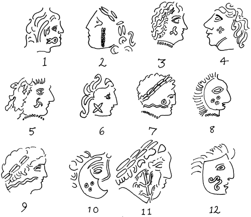
A Special Note on Tattoo research.
The tattoo designs for the new Pritanoi units were based on the following sources.
Woad, Tattooing and Identity in Later Iron Age and Early Roman Britain, by Gillian Carr, Oxford Journal of Archaeology, Volume 24 Issue 3, Pages 273 - 292.
Ms. Carr’s work examines crescent shaped objects found only among the insular Celts, which she believes are woad grinders, which were previously interpreted as “horse trappings”.
Finding Blue, Catherine Cartwright-Jones.
Ms. Cartwright-Jones is one of the world's foremost experts on henna and woad body art, and has successfully redeveloped the necessary techniques for making woad body paint, thought by many other tattoo artists and re-constructionists to be impossible.


 Reply With Quote


 from Megas Methuselah, for some information on Greek colonies in Iberia.


 - Horseman of the


 )
)


Bookmarks